
By Thierry Valle
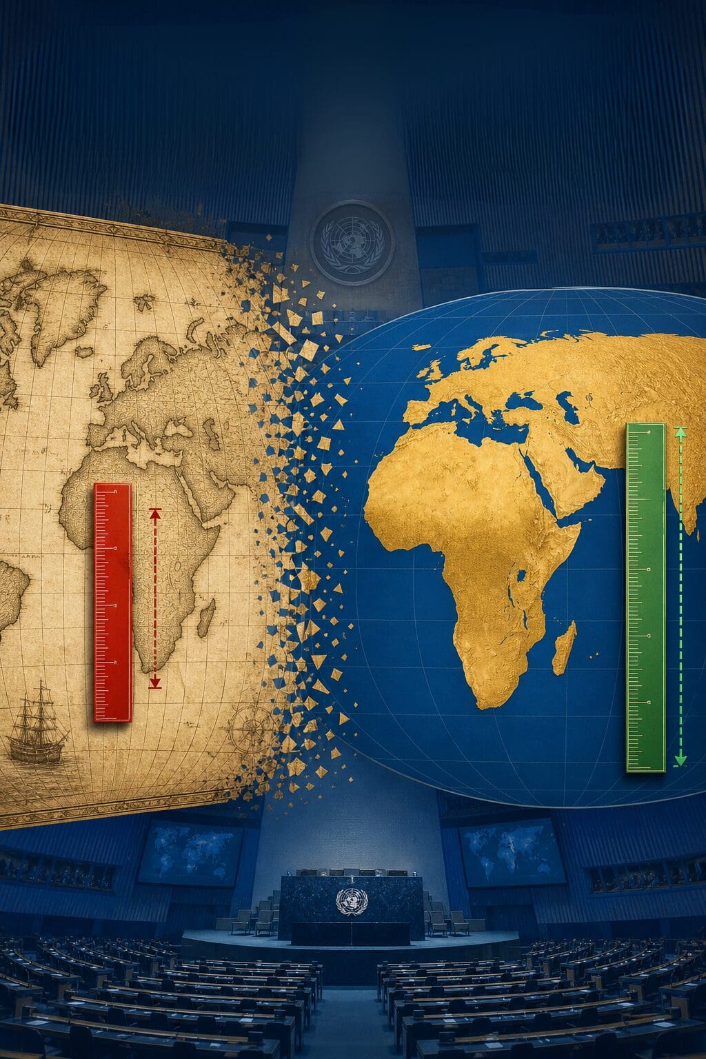
Brussels (1st May 2026) — Classroom and UN chamber world maps are often seen as neutral, yet they remain based on Gerardus Mercator’s 1569 design.
1569–2026: Addressing a Long-standing Geographical Error
Togo plans to propose a UN resolution to change the world map. Backed by several African Union member states, including Ghana, Senegal, and South Africa, the proposal seeks to be introduced during the 81st General Assembly session in September 2026. This brings to light the political nature of cartography.
By confronting the dominance of the Mercator projection, Togo aims to rectify a visual distortion that has minimized Africa’s importance for centuries.
This proposal has stirred debate, aiming to replace the Mercator projection with a map that accurately reflects continent sizes. The argument is that the current map reflects a 16th-century European perspective, underscoring the need for geopolitical justice and geographical truth.
From Historical Bias to Visual Distortion
Understanding Togo’s proposal requires revisiting geography’s history. Gerardus Mercator’s 1569 projection revolutionized navigation with its straight-line courses. However, it distorted sizes, making Greenland appear as large as Africa.
This distortion mirrored 16th-century worldviews. Despite Europe’s 19th-century scientific revolution, the map remained unchanged, reflecting neglect of African sovereignty and perpetuating pseudoscientific racial theories.
In 1839, Samuel George Morton attempted to rank races by skull size. Mercator’s map and these pseudosciences shared a common classification system centering on Europe.
Shaping Perception, Shaping Power
As far-right ideologies resurge, addressing cartographic bias becomes essential.
Movements like Black Lives Matter challenge marginalization. The removal of Edward Colston’s statue in 2020 and the European Commission’s 2021 acknowledgment of systemic racism show that visual hierarchies can be dismantled.
Africa’s Mercator-induced ‘smallness’ reinforces exclusionary policies, diminishing the humanity of its people.
Togo’s push emphasizes that map perception shapes policy. Decision-makers conditioned to view Africa as smaller may unconsciously assign lesser importance, necessitating projections like Gall-Peters and Mollweide for accurate representation.
Geographical Hierarchy in Focus
This initiative coincides with a sensitive diplomatic moment, following a March 2026 resolution on the slave trade, on which many Western nations abstained.
While they argue against ranking suffering, maintaining Mercator’s projection implies acceptance of a ‘geographical hierarchy’ that resists dismantling dominance structures, marginalizing Africa visually despite recognizing its historical victimhood.
France’s Diplomatic Opportunity
For France, this resolution presents a diplomatic opportunity. Criticized for abstaining on slavery, Paris can now demonstrate change by supporting Togo’s call for a fair map, aligning universalism with global reality.
Adopting a more accurate map would symbolize increased space for African voices in global governance.
The Map as a Symbol of Justice
Maps hold power, defining centrality and periphery.
Togo’s effort draws African and diaspora attention, urging nations to seize this opportunity for justice.
Correcting the map transforms mental geography, reshaping perceptions of importance. A perspective shift would be a symbolic act of redress in a world marred by bureaucracy and far-right rhetoric.
World maps should depict true proportions, ensuring everyone finds their rightful place.
Sources
Anadolu Agency, Pouvoirs d’Afrique, Mali Actu, Yeni Şafak, Travel Card Journal, AIP, Prémices Média, Togolese Diplomacy on Twitter.


Leave a Reply